| Rating | ★★★★☆(4/5) |
| Overall Difficulty | Moderate |
| Navigation Difficulty | Easy |
| Distance | 1.2 miles roundtrip |
| Time | 1.5 hours |
| Terrain | Strenuous climbing, 400 feet of elevation gain |
| Best Seasons | Spring, Summer, Fall |
| Family Friendly | Yes |
| Dog Friendly | Yes |
| Accessible | Yes |
Highlights
- Panoramic views from the observation deck
- Pretty mountain scenery
- Exhibits about the mountain and surrounding area
Hike Summary
Located 2 hours north of Atlanta and rising 4784 feet above sea level, Brasstown Bald is the highest peak in Georgia. The hike to the top is comparable to many of the other state highpoints in the Southern Appalachians: the parking lot is very close to the summit, and the hike is a short but steep trip on a paved path. For not much effort, you can summit a state highpoint, enjoy good views, and learn more about this mountainous region in Georgia.
From the parking lot, the mountain looks like a small, rounded, forested hill, as pictured below. You can find the trail leading to the observation tower between the two buildings at the base.

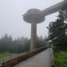
The summit tower as seen from the parking lot

In the summer, mountain laurels bloom pink along the trail

The sign marking the summit of Brasstown Bald

Lush forest with mountain peaks in the distance

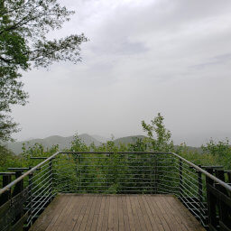
Hazy mountain views from the observation deck
Important Information
Dogs are allowed on leash but are not permitted inside any buildings. While the climb may be difficult, this is still a family friendly hike. And, if you are unwilling or unable to hike to the top, there are shuttles that drive to the top -- included with the entrance fee. You can visit during any season, though the facilities are only open March-December and winter storms may periodically close the road. Expect to see many people no matter when you go.
Directions
From Atlanta, take Georgia Highway 400 north, then continue onto U.S. Highway 19. In Dahlonega, follow signs and turn right to remain on U.S. Highway 19. This road and much of the remainder of the route are extremely curvy with several hairpin turns. Turn right onto Georgia Highway 180. Once on this highway, there will be signs pointing the way to Brasstown Bald. Make a slight left onto Georgia Highway 180 Spur, and the road ends at the entrance booth and parking area for the mountain.
Google Maps Directions
Parking, Fees, and Facilities
You must pay a park entrance fee of $5/person (age 16+) before parking ($3/person after hours); interagency passholders are admitted for free with up to 3 other guests.
The facilities are typically open Thursday-Sunday during business hours from March-December, but this can change due to weather. At the bottom, there are flush toilets, a gift shop, and a visitor center. At the top, there are flush toilets, an observation deck, a theater, and nature exhibits.
Nearby Hikes
Great Smoky Mountains National Park, Tennessee
★★★★☆(4/5)
South Carolina
★★★☆☆(3/5)