| Rating | ★★★★★(5/5) |
| Overall Difficulty | Easy |
| Navigation Difficulty | Easy |
| Distance | 1.7 miles roundtrip |
| Time | 1 hour |
| Terrain | A few hills |
| Best Seasons | All |
| Family Friendly | Yes |
| Dog Friendly | No |
| Accessible | No |
Highlights
- Virgin, 300+ year old pine forest
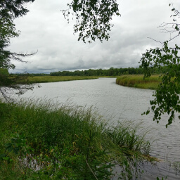
- Marshy views at Moose Brook
Hike Summary
The Lost Forty is a gem in the Chippewa National Forest and the entire state of Minnesota. Thanks to a surveying error that mapped 40 acres of forest underwater, these trees were spared from logging. Now you can visit trees over 100 feet tall and as old as the United States with some so wide you can't reach all the way around when you hug them. Due to the extensive logging of Northern Minnesota, there are few places left in the state to view pine trees this large. If you're ever in the area, this is one place you need to stop.
The Chippewa National Forest website isn't clear about their rules regarding pets, but it is safe to assume dogs are allowed in the portion managed by the Forest Service. It is important to note that about half of the trail is within a State of Minnesota Scientific and Natural Area, which bans all pets; if you are hiking with a dog you must stick to the area closest to Lost Forty Road that you drove in on. This is an excellent family friendly hike, and what an amazing experience for your kids to see such gigantic trees! There isn't much information about seasonal access to the Lost Forty, but I found a few pictures of people visiting in the snow. As such, I would assume you can hike this in all four seasons, but my guess is that the biggest difficulty is driving here -- there are no guarantees that they plow the dirt roads. I visited on a lovely fall Saturday afternoon and saw a decent amount of people, though it didn't feel overly crowded. Expect even more people during the summer.
Even the drive here is scenic, especially in fall -- just look at the picture below! The trail starts across the road from the parking area. This first part has the largest trees in the forest, some with diameters up to four feet wide. I took the picture at the top of the page not far from the trailhead, and I must say it is difficult to capture the majesty of these trees in a photo. There are a few interpretive signs scattered throughout this hike, but storm damage, vandalism, and/or old age are apparent and make reading difficult or impossible on some. Even so, these signs finally taught me how to differentiate between red and white pines (red pines have reddish brown bark that looks like a jigsaw puzzle while white pines have greyish bark with deep grooves).

Trees with yellow autumn leaves line the dirt road (remember this Windows XP desktop background?)
View full size
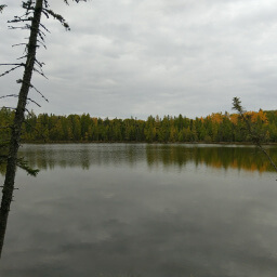
Ahead there will be an intersection just before a hill where you can choose to continue straight to Moose Brook (included in the total mileage at the top of the page), or continue the loop. The trail to Moose Brook has the majority of elevation change for the hike, with some slight hills and a staircase leading down to the brook at the end. You exit the tree canopy near the brook, with a pretty change in scenery as pictured below. There is a bench here where you can sit and enjoy the sound of running water. Head back to the main loop trail, then turn right to continue the hike. About halfway between the top of the loop and the dirt road, there will be a bench and an overlook -- the trees mostly block the view, but you can see a nice hill in the distance (covered in flaming yellow birch trees in fall). Stay straight for the remainder of the hike until you return to the dirt road. This destination is worth the long drive and is a truly special place in Minnesota. Put this place on your list and be sure to visit next time you head up north! Let me know what you think in the comments section below, and be sure to use #nocoastbestcoast on Twitter and Instagram!


Directions
The Lost Forty are pretty much in the middle of nowhere (obviously you wouldn't just lose 40 acres of forest if they were somewhere important). The best route depends on where you start from, so use the Directions link below if you are starting from a different location than Grand Rapids or Bemidji.
From Bemidji, take U.S. Highway 71 north to Blackduck. Turn right on Atwood Road (County Road 30). This road eventually changes name to County Road 13. In Alvwood, turn left onto Minnesota Highway 46, then turn right on County Road 29. From County Road 29, head north on the dirt road County Road 26. Turn left on Lost Forty Road and continue until you see the parking area on the left and a Lost Forty sign on the right.
From Grand Rapid, head west on U.S. Highway 2. After driving through Deer River, turn right onto Minnesota Highway 46. Turn right onto County Road 34 (which eventually changes name to County Road 4), then turn left onto County Road 126 (dirt road -- alternatively you could continue straight on Minnesota Highway 46 until you reach County Road 29). Turn right onto County Road 29. From County Road 29, head north on the dirt road County Road 26. Turn left on Lost Forty Road and continue until you see the parking area on the left and a Lost Forty sign on the right.

Google Maps Directions
Parking, Fees, and Facilities
Parking is free! Park along the side of the road if the parking area is full. There is a pit toilet near the parking area.
Nearby Hikes
Scenic State Park, Minnesota
★★★★★(5/5)
Lake Bemidji State Park, Minnesota
★★★☆☆(3/5)
Lake Bemidji State Park, Minnesota
★★★★☆(4/5)
Schoolcraft State Park, Minnesota
★★★★★(5/5)