| Rating | ★★★★☆(4/5) |
| Overall Difficulty | Hard |
| Navigation Difficulty | Easy |
| Distance | 6 miles roundtrip |
| Time | 3.5 hours |
| Terrain | Strenuous climbing, 1200 feet of elevation gain |
| Best Seasons | Spring, Summer, Fall |
| Dog Friendly | Yes |
| Accessible | No |
Highlights
- Summitting the tallest peaks in Ventura and Kern Counties
- Views of the Central Valley and the Pine Mountain Ridge
- Shady pine forest and cool mountain air
Hike Summary
This is your chance to summit two California county highpoints; at 8847 feet above sea level, Mount Pinos is the highest point in Ventura County, and at 8822 feet, Sawmill Mountain is the highest point in Kern County. Not only do these mountains offer incredible views, their cooler high elevation temperatures and pine forest offer a great escape from the urban heat of LA.
The trail begins a 600 foot climb to the summit of Mount Pinos almost immediately after you leave the parking area for the forest. Since the trail is a road, the slope is relatively gradual. After about 300 feet of elevation gain, the trail levels out as you reach a beautiful meadow, which may be covered in wildflowers depending on the season as pictured below. On the west end of the meadow, you'll be able to see the dome of Mount Pinos's summit with a tower rising above the trees.

Yellow wildflowers blooming on Mount Pinos

The view south from the electrical equipment atop Mount Pinos

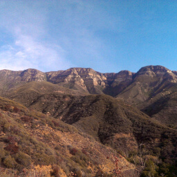
The Pine Mountain Ridge as seen from the Condor Observation Site

The giant stone cairn adorned with prayer flags marking the summit of Sawmill Mountain

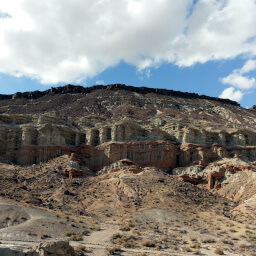
The flowery terrain of the San Emigdio Mountains as they descend into the Central Valley

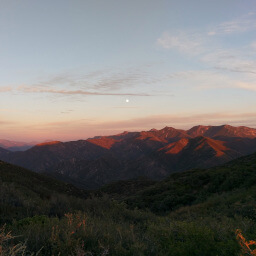
The view north from Sawmill Mountain into the Central Valley's patchwork of farm fields and orchards
Hiked on Saturday, August 29th, 2015 by Ricky Holzer
Important Information
Rules about dogs are not directly specified by the Forest Service, but dogs are most likely allowed on leash and possibly off leash. This is a strenuous climb at high elevation unsuitable for children. Spring, summer, and fall are the best seasons for this hike since it will be covered in snow during the winter months. The high elevation means that it will be nice and cool, even when temperatures are hot in the LA area. This is a moderately popular trailhead. Expect to see many people on your way to Mount Pinos, but fewer make the trip to Sawmill Mountain since it requires uphill on the return trip.
Directions
From Los Angeles, take Interstate 5 north. Past Gorman, take the exit for Frazier Mountain Park Road and turn left. Drive through the town, then turn right on Cuddy Valley Road. Follow the road as it winds up the mountain and park in the large parking lot where the road ends.
Google Maps Directions
Parking, Fees, and Facilities
Parking is free during the warm seasons. In the winter, this becomes a popular cross country skiing trail and an Adventure Pass is required. There are pit toilets in the lot but no water is available.
Nearby Hikes
Los Padres National Forest, California
★★★★★(5/5)
Los Padres National Forest, California
★★★★★(5/5)
Angeles National Forest, California
★★★★☆(4/5)
Red Rock Canyon State Park, California
★★★★☆(4/5)