| Rating | ★★★★☆(4/5) |
| Overall Difficulty | Moderate |
| Navigation Difficulty | Easy |
| Distance | 7 miles roundtrip |
| Time | 4 hours |
| Terrain | Hilly |
| Best Seasons | Spring, Summer, Fall |
| Family Friendly | No |
| Dog Friendly | Yes |
| Accessible | No |
Highlights
- Escape the crowds found in other parts of the park
- Great variety of landscapes
- Beautiful scenery
Hike Summary
If you're looking for a long hike in Sibley State Park, look no further than the Equestrian Loop in the northwest corner of the park. Fewer people visit this part of the park-- I went during Memorial Day weekend, and only encountered two others on horseback and no others on foot -- allowing you to enjoy the scenic meadows in peace.
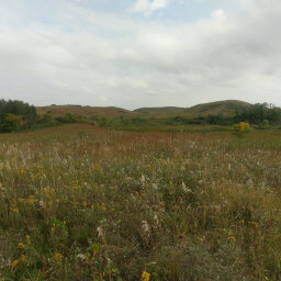
This hike starts and finishes exactly the same as the route described in the Mount Tom post. The only difference is that after reaching the dirt road after Little Mount Tom, turn right rather than left, then follow the road and look for the trail on the left side of the road that appears shortly after the intersection with another dirt road. Once you are on the trail, continue straight through the equestrian area. You'll emerge from the forest and into a grassy wonderland, like pictured below.

The prairie in the forest in Sibley State Park
If you have the stamina, I highly recommend doing this hike because it is much more interesting than the hike to Mount Tom. Connect with me using the social media links below and share your adventures!
Directions
Sibley State Park is about 2 hours from the Twin Cities near the town of New London. I highly recommend taking Minnesota Highway 55 -- it's a two lane highway with very little traffic (even over Memorial Day weekend). Once you get to Paynesville, take Minnesota Highway 23 towards Willmar, then turn right onto Minnesota Highway 9 to go through New London. Turn left on County Road 148 and continue straight when you come to the intersection with U.S. Highway 71. The ranger station will soon be on your right.
Google Maps Directions
Parking, Fees, and Facilities
Like all Minnesota State Parks and Recreation Areas, you must pay a vehicle entry fee of $7 per day or $35 for an annual pass (highly recommended if you frequently go to Minnesota State Parks).
Nearby Hikes
Sibley State Park, Minnesota
★★★☆☆(3/5)
Glacial Lakes State Park, Minnesota
★★★★☆(4/5)
Lake Maria State Park, Minnesota
★★★★☆(4/5)
Sand Dunes State Forest, Minnesota
★★☆☆☆(2/5)