| Rating | ★★★★★(5/5) |
| Overall Difficulty | Very hard |
| Navigation Difficulty | Easy |
| Distance | 10.8 miles roundtrip |
| Time | 6 hours |
| Terrain | Strenuous climbing, 4000 feet of elevation gain |
| Best Seasons | Spring, Summer, Fall |
| Dog Friendly | Yes |
| Accessible | No |
Highlights
- Summit the tallest mountain near Tucson
- Unbeatable panoramic views
- Shady forest to beat the heat
Hike Summary
While Mount Lemmon seems to get all of Tucson's fame and glory, lesser known Mount Wrightson is perhaps a more fun and scenic climb thanks to the lack of development on its summit and heavily shaded trail to shield you you from the Arizona heat. Rising over 4,500 feet above the Sonoran Desert to a respectable 9,456 feet above sea level, Mount Wrightson is the tallest mountain in the vicinity of Tucson and the highest point in Santa Cruz County. Though the top's panoramic views extending to Tucson in the north and Mexico in the south are the primary reward, the entire hike is chock full of scenic viewpoints -- each of which you will definitely use as an excuse to take a breather on this high altitude climb with over 4,000 feet of elevation gain. Despite the physical demands of the hike, you'll forget the aches and pains in your legs and look back on this hike with fond memories of natural splendor and personal achievement.
The Old Baldy Trail described here is one of two primary routes to the top, the other being the Super Trail. These trails meet near Josephine Saddle to create a figure 8 on the mountain and can be combined to make a more interesting loop hike. Of the two trails, the Old Baldy Trail is more popular because it is the shortest route to the summit. Though the Super Trail is longer, it's a more gradual ascent, which may be preferable to some people.
No matter which lot you park in, walk to the north end of angled spaces on the eastern side of the picnic area to find the Old Baldy Trailhead -- the Super Trailhead begins on the south end of the lot near the restrooms. From the parking lot, Mount Wrightson and its jagged rocks prominently rise above the forest in front of you. Although it may not look like it, the mountain towers 4,000 feet above where you stand. The trail starts traveling gently uphill until you reach a rusty metal sign indicating you take a left turn turn for the Old Baldy Trail. The steepness of the trail will increase, then you'll pass a sign informing you are now entering the Mt. Wrightson Wilderness. Occasional breaks in the trees reveal glimpses of Mount Wrightson taunting you as you make seemingly little progress, as pictured below.

Rocky Mount Wrightson looms above the treeline
Also at the saddle, you'll find a memorial (pictured below) to three Boy Scouts who died on the mountain during an unexpected snowstorm in November 1958. Six boys from a troop in Kansas were day hiking the mountain on what seemed like a perfect day: the forecast predicted temperatures in the 70s and some wind. After three grew tired and turned around, the weather started to turn on the three remaining hikers, beginning as wind and rain then freezing to snow -- 6 inches of snow fell on Tucson (!), with several feet falling on the high mountain. Despite the efforts of 700 volunteers, no one was able to locate the boys until their bodies were found three weeks later just east of this saddle. This serves as a tragic reminder that mountains can be dangerous, even when you think you are prepared.

A sign memorializing the deaths of three young Boy Scouts during a freak snowstorm

Openings in the trees provide beautiful views

Snow and ice at Bellows Spring

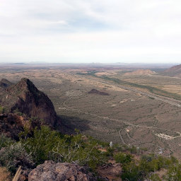
Near treeline, you can start to see civilization along Interstate 19

The view southeast from the Baldy Saddle
Finally, after all your effort, you will reach the summit. A sign histories a previous fire lookout that was built on the summit (imagine having to do this hike every time you had to report to work!) and eventually dismantled. As the highest peak near Tucson, you have an unobstructed 360 degree view, and with the exception of Mt. Graham and Chiricahua Peak to the northeast and east respectively, nothing else in view is higher than you. The two pictures below do not do justice to the sheer splendor that is this panoramic view of Tucson and its surrounding mountain ranges.

The view southeast from the summit of Mount Wrightson

Looking north from the summit towards Tucson and Mt. Lemmon
While this is no doubt a challenging hike, the effort is more than worth it for this tremendously beautiful trail through pines to the top of the tallest mountain near Tucson. I cannot recommend this hike enough, and I hope you accept the challenge yourself! Connect with me using the social media links below and share your adventures!
Hiked on Saturday, December 22nd, 2018 by Ricky Holzer
Important Information
Dogs are permitted on leash. With over 4000 feet of elevation gain and over 10 miles of hiking, this is no place for kids to hike; nearby kid-friendly alternatives include the Nature Trail to the amphitheater or the accessible trails at the Proctor Parking Area or Whitehouse Picnic Area -- read the Hiking Trails Descriptions published by the Friends of Madera Canyon for more information.
The best seasons for hiking are fall and spring when temperatures are mild at the base and the summit is clear of snow. In the summer, this is a good trail to beat the heat thanks to the trailhead starting at a cooler 5,500 feet of elevation, the trail's location on the shady north side of the mountain, and the shade of the pines in lower elevations. Winter hikes may also be possible, depending on snow conditions at the top -- a good estimate for summit snow/ice conditions is to google weather and webcams on nearby Mount Lemmon, which is only a couple hundred feet shorter than Mount Wrightson and is heavily monitored thanks to its ski resort. Even if there is no snow on top, ice is usually present at the higher elevations in the winter; I highly recommend bringing trekking poles and/or traction devices like Yaktrax to prevent you from slipping and falling.
In any season, bring ample water and snacks to fuel this grueling journey to the top and wear sun protection, especially above treeline where shade is minimal and sunburn risk is higher due to the altitude. Remember, the thin, dry air at higher altitudes makes it easier to become dehydrated. Bears, rattlesnakes, and mountain lions may be encountered, so know what to do around dangerous wildlife. At over 9,400 feet, climbing Mt. Wrightson may cause some people to experience altitude sickness, which typically occurs above 8,000 feet. Since most summit this peak as a day hike and start the day from the desert lowlands of Tucson, you won't have a chance to acclimatize your body. Learn to recognize the signs of altitude sickness and descend if feeling sick -- you'll immediately feel better once you reach lower altitudes.
This is the most popular route to the top, so expect to see plenty of people. The first part of the trail will be the most crowded since many hikers turn around at Josephine Saddle. You will see fewer people the closer you get to the top, and there will probably be people resting at the summit.
Directions
From Tucson, take Interstate 10 to Interstate 19 heading south. Exit the highway at Continental Road in Green Valley, then turn left. From here on, brown signs for Madera Canyon will indicate the turns and assure you are heading the correct direction. Turn right at White House Canyon Road. Continue following the paved road all the way until the end at the Mount Wrightson Picnic Area, then find parking.
Google Maps Directions
Parking, Fees, and Facilities
Parking currently costs $5 per vehicle, paid in cash or check at the self-service kiosk pictured below and displaying thes stub on your dashboard. Coronado National Forest Weekly ($10) and Annual Passes ($20) are available for purchase at the Santa Rita Lodge, which you'll pass in Madera Canyon on the drive to the trailhead, or at any district office (found in various places in southeastern Arizona). The Forest Service also honors all Interagency Annual Passes. More information is available at the Coronado National Forest Passes and Permits Page. Note that at the time of writing, there is a proposal to increase daily fees to $8 and annual pass prices to $40 that may be implemented sometime in 2019.

Pay your fees at this kiosk near the Old Baldy Trailhead