| Rating | ★★★★☆(4/5) |
| Overall Difficulty | Easy |
| Navigation Difficulty | Easy |
| Distance | 1 mile roundtrip |
| Time | 30 minutes |
| Terrain | Hilly |
| Best Seasons | All |
| Family Friendly | Yes |
| Dog Friendly | No |
| Accessible | No |
Highlights
- Great views across the prairie to the east
- Potential to see bison and other wildlife
Hike Summary
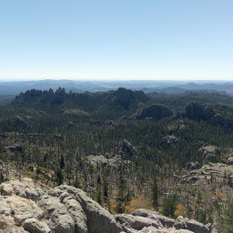
Rankin Ridge, pictured below as seen from the drive to the trailhead, is the highest point in Wind Cave National Park, but it's easily accessed via a gently sloping mile long loop trail. This hike is a must do for any first time visitors to the park. While the park is most famous for its underground wonders in Wind Cave, that's literally only half of the park! The environment here is quite unique since it is the crossroads of eastern and western flora and fauna. From the top of Rankin Ridge, you can see this mixture in action as you peer down on pine forest transitioning to prairie grassland.

Rankin Ridge with a prairie dog town in the foreground as seen on the drive to the trailhead

A bison grazing just beyond the trailhead

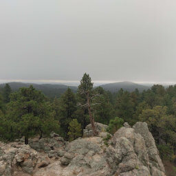
Near the top of the climb you'll be rewarded with nice views

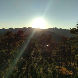
Looking eastward from the top of Rankin Ridge at the rolling prairie below

The hills to the south as seen from Rankin Ridge
Important Information
Dogs are not allowed on trails in Wind Cave National Park. This is an excellent family hike thanks to the short distance and incredible views. You can hike this trail in all seasons, but winter weather may temporarily close roads in the park. In addition, avoid this area during thunderstorms, common in summer. Since this hike has some of the best views in the entire park and is also one of the easier trails, expect to see many people, especially during the peak summer travel season.
Directions
From Custer, take U.S. 385 south towards Wind Cave National Park. After entering the park, turn left onto South Dakota Highway 87. This road has many tight turns as it winds through the hills, even passing over itself at one point. Once the road has straightened out and reaches a prairie dog town, a sign will direct you to turn right to reach the parking area for Rankin Ridge.
From Rapid City, take South Dakota Highway 79 south. After passing Hermosa, turn right onto South Dakota Highway 36. Continue straight (towards Custer) as the highway intersects with U.S. Highway 16A. Turn left onto South Dakota Highway 87. In about 13 miles, turn left after the pullout for the prairie dog town on the road signed for Rankin Ridge.
Google Maps Directions
Parking, Fees, and Facilities
Unlike most national parks, there is no park entrance fee. There are no facilities near this lot, so travel to the visitor center for flush toilets, water, a gift shop, a staffed information desk, and educational exhibits about the park.
Nearby Hikes
Wind Cave National Park, South Dakota
★★★☆☆(3/5)
Custer State Park, South Dakota
★★★★☆(4/5)
Custer State Park, South Dakota
★★★★★(5/5)
Black Hills National Forest, South Dakota
★★★★☆(4/5)