| Rating | ★★★★★(5/5) |
| Overall Difficulty | Hard |
| Navigation Difficulty | Medium |
| Distance | 8.8 miles roundtrip |
| Time | 7 hours |
| Terrain | Hilly, 1000 feet of elevation gain |
| Best Seasons | Spring, Fall, Winter |
| Family Friendly | No |
| Dog Friendly | No |
| Accessible | No |
Highlights
- Bathing in a natural hot spring
- Rugged desert scenery and views of the Colorado River
- View of Liberty Arch
Hike Summary
I was expecting Arizona Hot Spring to be cool, but I never imagined that this hike would be one of the most memorable of 2019! In addition to nature's spa, you'll find a stone arch, absolutely beautiful views of the Colorado River, and desert scenery every step of the way. Forget the other attractions in Las Vegas, the nearby hiking is the real destination.
The hike starts by following a trail underneath the highway bridges and into the white gravel wash pictured below. The trail isn't well-defined here since the wash is wide and plants are spread thin, but the footsteps in the soft, crunchy rock underfoot will give you a general direction to head.

The wide wash at the start of the hike
I'll describe the remainder of the hike as I did it: going to Arizona Hot Spring first. Further down the wash, look for a neon streamer tied to a bush indicating where you leave the wash by going up a hill to the left. After some rolling terrain, you'll begin a steep descent into the canyon at around the point pictured below.

Looking down into the canyon
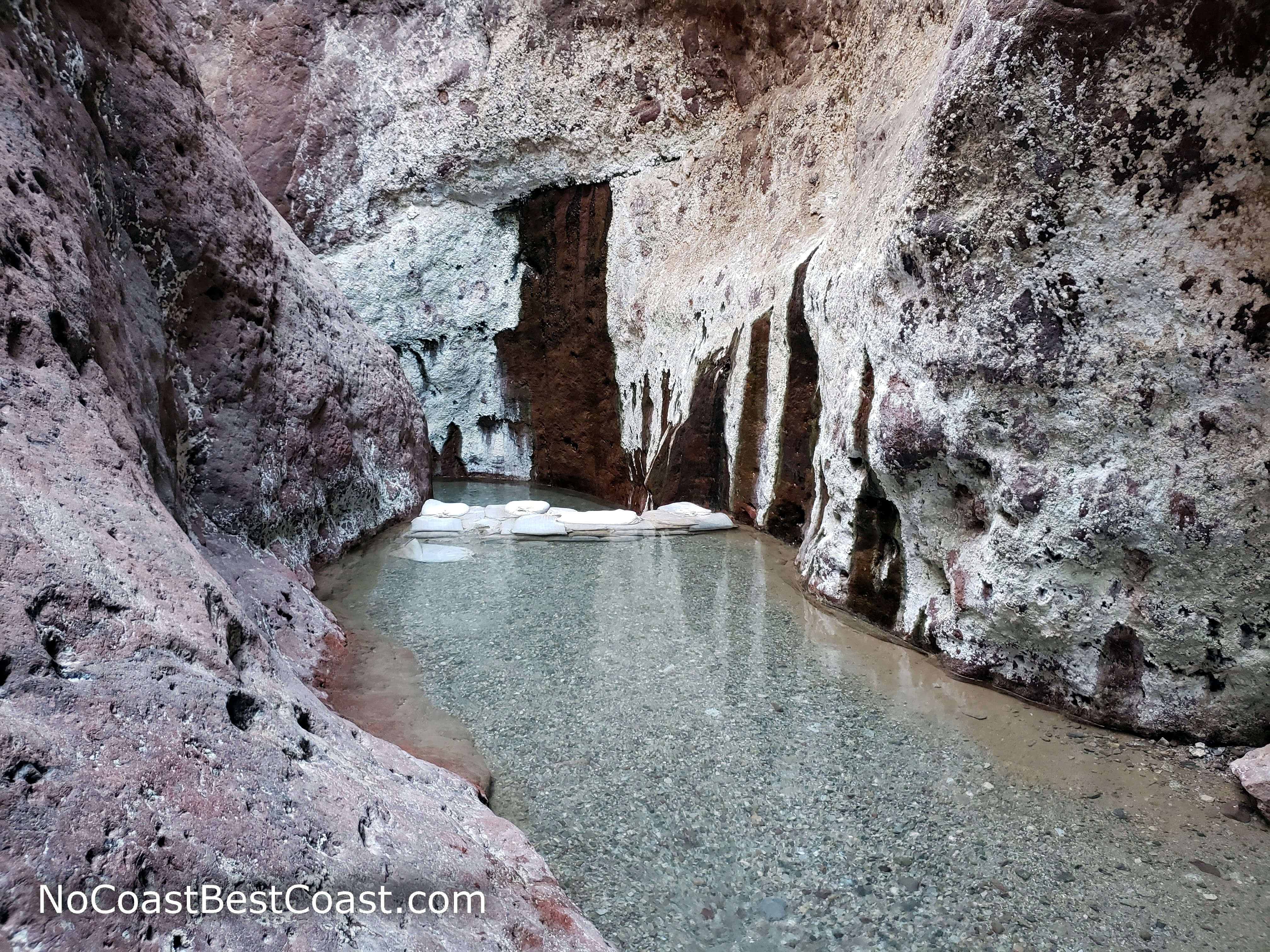
The clear, steaming waters of Arizona Hot Spring
At the end of the hot spring, you'll find the 20-foot metal ladder pictured below. Carefully descend (especially since your shoes will be wet), and continue following the "creek" through the slot canyon. On the right, watch for a marker and some paint on the right side (which of course is hidden by a tree) pointing uphill. If you reach the campsite by the river, you've gone too far.

Descending this ladder in wet shoes is quite scary

The Colorado River is a bright green here

The slot canyon and it's vertical rock walls
At some point after cresting a hill, you'll see the piece of old mining equipment in the first picture below. Up another hill beyond that, you'll reach the nice view in the second picture below, with the snaking trail clearly visible on the bottom right and the mountain hiding the arch directly in the center.

Old mining equipment on the way to Liberty Bell Arch

The rugged desert terrain with the arch in the distance


The view of the Colorado River looking south
This hike is chock full of interesting scenery and worthwhile stopping points. Visit here when you want an escape from the excess of Las Vegas, and stop by the Hoover Dam on the way back for some less active fun! Connect with me using the social media links below and share your adventures!
Important Information
While dogs are permitted on all trails in the park, they are not allowed in bathing areas, including the hot spring. In addition, a 20-foot vertical ladder would dogs from completing the loop. Instead, you can skip the hot springs and take the White Rock Canyon Trail to the Colorado River and back or go to the Liberty Bell Arch.
This is not a family-friendly hike, nor are any of the alternatives family-friendly due to the distance and elevation gain required (the shortest hike to Liberty Bell Arch is still over 5 miles!). You can hike here in the fall, winter, and spring, but this trailhead is closed during the oppressive summer heat from mid-May until the end of September. The hot spring makes this a popular destination -- on the Friday I visited, there were several groups sitting in the hot spring, and plenty more people near the Colorado River.
Directions
From Las Vegas, take Interstate 11/U.S. Highway 93 towards the Hoover Dam. After crossing over the Pat Tillman Memorial Bridge over the Colorado River into Arizona, watch for a sign indicating White Rock Canyon Trailhead Access. Use the left turn lane after the sign, and follow the road to the parking lot.
Google Maps Directions
Parking, Fees, and Facilities
Unlike the rest of the park, no fee or pass is required at this trailhead parking lot. There are no facilities here.
Nearby Hikes
Valley of Fire State Park, Nevada
★★★☆☆(3/5)
Red Rock Canyon National Conservation Area, Nevada
★★★★☆(4/5)