| Rating | ★☆☆☆☆(1/5) |
| Overall Difficulty | Moderate |
| Navigation Difficulty | Easy |
| Distance | 3.8 miles roundtrip |
| Time | 2 hours |
| Terrain | Hilly |
| Best Seasons | Spring, Summer, Fall |
| Family Friendly | No |
| Dog Friendly | Yes |
| Accessible | No |
Highlights
- Solitude in the forest
- Not much else.
Hike Summary
If I chose one word to characterize this hike in Mississippi Palisades State Park, it would be disappointment. As someone who loves climbing anything labeled a high point, I was immediately attracted to this overlook, especially since both the official park map (linked at the bottom of the page) and the Natural Atlas map above both use a camera symbol to imply there is scenic beauty at the end of this hike. However, this trail told the story of poor park maintenance and the stereotype that Midwesterners would rather drive to an overlook than spend any time earning their views. This is one of only a handful of 1-star hikes on this site, and I've reviewed it here precisely so you don't make the same assumptions I made and waste your time.
From the parking area, walk across the grass to the gravel trail/service road signed for "high point", then begin the gradual climb to the top of the bluffs. Throughout the hike, you'll see evidence that visitors used to be able to drive to the High Point overlook, including sections of pavement and a clearing near the overlook that used to be a parking lot. The climb isn't particularly hard, but the effort makes you expect a reward, especially because there's nothing to look at but forest.

The wide trail heading uphill into dense forest

You'll have to climb over numerous fallen trees on this hike

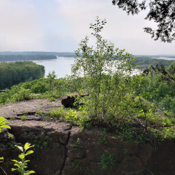
The "view" from High Point

This fungus on a dead tree was the most exciting thing on the hike

The "view" from Rock Top
Important Information
Dogs are allowed on leash. Don't take your family on this hike: it's too long, too hilly, and lacks any scenic value beyond the forest. You can hike in the three warm seasons and possibly during the winter; some of the trails in the park are used for cross country skiing, but the park's website does not specify which trails nor if hiking is allowed on ski trails. The uphill climb at the very beginning of the hike deters most people, so this is one place in this popular park you can go for solitude.
Directions
Mississippi Palisades State Park is about 3 hours from Chicago. Take Interstate 290 to Interstate 88 west. After about 60 miles, take the exit for Interstate 39/U.S. Highway 52 heading north. Take the exit for Illinois Highway 64, then turn left. Turn right onto U.S. Highway 52. Continue straight onto Illinois Highway 84, continue past the south park entrance, then turn right into the north park entrance. Park in the small lot on the left side immediately after turning into the park. If full, more parking is available at the park office.
Google Maps Directions
Parking, Fees, and Facilities
Parking is free! Restrooms are available by the park office.
Nearby Hikes

Mississippi Palisades State Park, Illinois
★★★★☆(4/5)
Mississippi Palisades State Park, Illinois
★★★★☆(4/5)

Bellevue State Park, Iowa
★★★★☆(4/5)

Bellevue State Park, Iowa
★★★☆☆(3/5)