| Rating | ★☆☆☆☆(1/5) |
| Overall Difficulty | Easy |
| Navigation Difficulty | Easy |
| Distance | 2 miles roundtrip |
| Time | 1 hour |
| Terrain | A few hills |
| Best Seasons | Spring, Fall |
| Family Friendly | Yes |
| Dog Friendly | Yes |
| Accessible | No |
Highlights
- Easy loop accessible from the campgrounds
- Collect another hiking club password
Hike Summary
This was the worst Hiking Club trail I've done thus far. The loop offers little scenery despite climbing to the top of a hill -- the dense forest blocks the view, and there is a hilariously placed park bench looking at nothing but trees. I recommend doing this hike in early spring or late fall when there isn't as much vegetation (this trail unfortunately isn't open in winter).
Like most Hiking Club trails, this is a family friendly hike. Dogs are allowed on leash. Know that this park has the most horseback riders of any Minnesota State Park, so watch where you step!
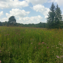
I recommend doing this loop clockwise so you can get the hill out of the way at the beginning. From the parking lot, head towards the amphitheater, then follow the trail south through a tall patch of fennel like pictured below. Turn left after walking past the cabins to follow the Maple Ridge Trail uphill (there should be blue signs for the Hiking Club) -- the other trail goes to Big Spring.


Really, the only reason you should do this hike is if you are collecting Hiking Club passwords. Otherwise, save your steps for something more remarkable, like Historic Forestville or the Big Spring Trail. If you do this hike for whatever reason, be sure to use the comment section below to let me know how it went and use #nocoastbestcoast on Twitter and Instagram!
Directions
Be careful when using navigation to direct you to this park! You must enter the park from the west side using County Road 118 after turning from County Road 5; otherwise if you enter from the north, you will run into a dead end at a closed bridge and will be unable to access the rest of the park.
From the Twin Cities, take U.S. Highway 52 south towards Rochester. On the south side of Rochester, take the exit for U.S. Highway 63 heading south. At the T intersection a bit after Racine, turn left to continue on U.S. Highway 63. Then in Spring Valley, continue heading straight onto Minnesota Highway 63 rather than staying on U.S. Highway 63. Turn right on County Road 5, then turn left on County Road 118 following the signs for Forestville State Park. The park office will be on the right hand side. Pay your fee, then turn right following signs for the amphitheater. Turn right again towards the amphitheater before the loops for the campgrounds and park in the lot on the right side.
Google Maps Directions
Parking, Fees, and Facilities
Like all Minnesota State Parks and Recreation Areas, you must pay a vehicle entry fee of $7 per day or $35 for an annual pass (highly recommended if you frequently go to Minnesota State Parks). There are pit toilets near the amphitheater.
Nearby Hikes
Forestville-Mystery Cave State Park, Minnesota
★★★★☆(4/5)
Forestville-Mystery Cave State Park, Minnesota
★★★★☆(4/5)
Forestville-Mystery Cave State Park, Minnesota
★★★★★(5/5)
Oxbow Park, Minnesota
★★★★☆(4/5)