| Rating |
★★★★★(5/5) |
| Overall Difficulty |
Hard |
| Navigation Difficulty |
Easy |
| Distance |
4 miles roundtrip |
| Time |
3 hours |
| Terrain |
Strenuous climbing |
| Best Seasons |
Spring, Fall, Winter |
| Family Friendly |
No |
| Dog Friendly |
No |
| Accessible |
No |
Highlights
- Views throughout with a spectacular summit panorama
- Fun climbing using steel cables
Hike Summary
Despite growing up an hour away from Picacho Peak and even attending a civil war battle reenactment in the park, I never once climbed to the top. Finally, one decade after moving out of Arizona, I've summited the peak on one of the most fun hikes I've ever done. During this challenging climb, you'll enjoy fantastic Sonoran desert views throughout and some intense, nearly vertical rock that you'll ascend with the help of permanent steel cables. This is an adventure you won't want to miss!
This no-nonsense hike starts on the north side of the peak, which looms overhead during the first half of the hike as pictured below. The uphill climb starts immediately and becomes steeper as you approach the mountain. Thanks to the cooler temperatures caused by nearly constant shade, vegetation is lush and green on this side of the mountain, especially in the winter and spring.

The start of the Hunter Trail with Picacho Peak looming above
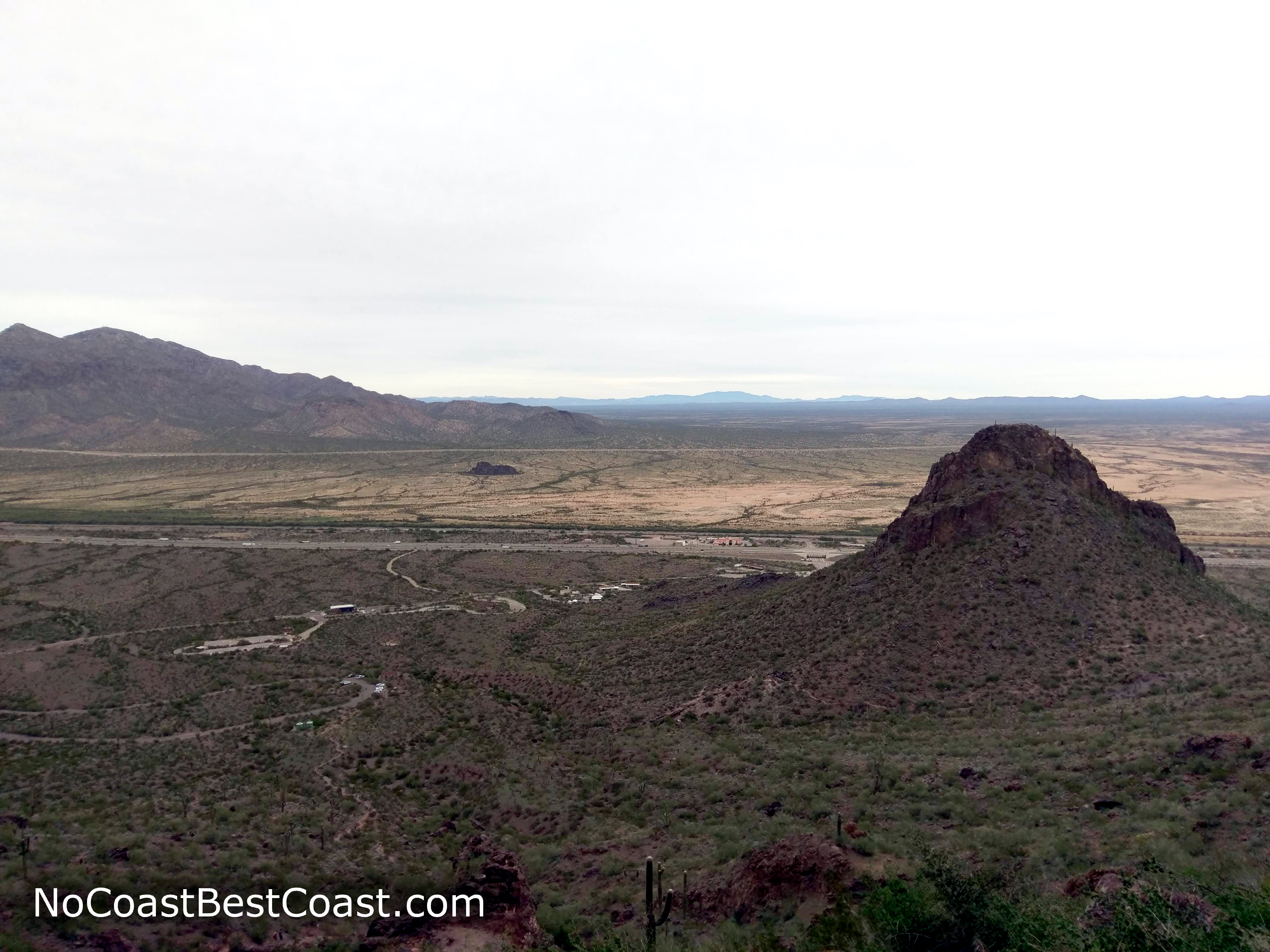
Unless you're in peak physical condition, you will need to stop and take a breather or two (or three or four). Looking back down on the trail, as pictured below, you can track your progress as the cars in the parking lot below start to shrink and the view of the highway and surrounding mountains improves.

The view looking back on the trail partway to the first saddle
White trail signs and spray-painted arrows will guide you when wayfinding is nebulous, as pictured below at a point where the trail hits a literal wall. These markings and signs are prevalent throughout the hike. Just past this point, you'll hike under a rock overhang, reminiscent of the type of place where native peoples built cliff dwellings like those at Mesa Verde National Park and Montezuma Castle National Monument.

Signs and white painted arrows direct you on the trail
After a long, strenuous climb, a bench and informational sign greet you at the top of the first saddle, as pictured below. You'll enjoy your first view to the south and west, a Sonoran desert landscape interrupted by a patchwork of green cropland with mountain ranges in the background.

A bench with a view at the first saddle
One of the reasons this hike is so difficult is you now have to descend a significant amount before beginning the final ascent to the peak, and this section will test your stamina with a steep ascent on the return trip. This is the first section assisted by steel cables, pictured below, which is testament to how steep this section is. Be mindful of other people on the trail and keep a safe distance. Some portions are only wide enough (or safe enough) for one person, so you will have to take turns if another party is ascending while you are descending or vice versa.

The start of the cables helping you on a steep descent
The trail winds around to the south side of the mountain where it converges with the Sunset Trail, the longer but more gradual approach to the summit. After the sign pictured below, the cable-assisted ascent begins. Unlike the previous part with cables which are usually shaded by the tall cliffs above, the remaining cable sections are all on the sunny south side of the mountain. As such, the cables may be hot (depending on the air temperature) and gloves are recommended.

The Sunset and Hunter Trails converge before a steep ascent to the summit
If you are afraid of heights, you may want to turn back now! A couple short sections are nearly vertical, like in the vertigo inducing picture below. In mountaineering terms, this would be considered
class 3 climbing, the point at which using hands is absolutely necessary and falls could result in injury or death. The cables help mitigate most of the danger, but you should still be cautious on these steep sections.

One particularly steep, cable assisted section
Just before the second saddle and the end of the cable-assisted sections, you'll reach what is possibly the scariest, most precarious looking part (pictured below): a short bridge and cable railings to protect you from falling off the steep ledge. While you may have thought it possible to climb the previous parts without the cables, this is definitely one place you'll be thankful for the cables. Once past, you are only a handful of switchbacks away from the summit.

Cables and a bridge protecting you on an otherwise precarious ledge
Compared to the excitement of the previous cable sections, the end of the climb will feel anticlimactic. However, you'll still feel relieved to be finished with most of the strenuous climbing and the views are spectacular, as shown in the three pictures below. Green veins of vegetation decorate the brown desert floor. To the west, you'll see farm fields and high mountains. To the east, you can see the interstate as it disappears in the urban haze of Phoenix and Tucson.

The view west across spidery desert washes and green farm fields

Looking north along I-10 on the summit of Picacho Peak
The rocky summit has plenty of places to sit and enjoy the view. Interestingly, there are many cattails growing at the top -- the only place you'll see them during the entire hike.

Cattails and a stone cairn adorning the summit, looking southeast
Remember, now that you're at the top of the peak, you're only halfway done with the hike! Take your time to safely descend, paying special attention on the steep cabled sections. On the steepest sections, it may be more comfortable to turn around and face the rock.
Overall, this hike is a must do for anyone near Phoenix or Tucson. While the trail isn't particularly long, the constant climbing and extreme cable-assisted steepness make it a unique and fun challenge. I hope you enjoy your hike! Connect with me using the social media links below and share your adventures!
Important Information
While dogs are allowed on leash in the park, the steepness of this trail (and lack of opposable thumbs to grip the cables) means this hike is not dog friendly. Leave any young children at home since this hike is much too difficult and potentially dangerous; adventurous preteens and older will love this hike.
This hike is best avoided in the hot summer heat, especially because the steel cables will be scaldingly hot. Even if you start early in the morning, you'll still need the cables on the descent, at which point they'll have had time to heat up. The peak is at a low enough elevation (3300 feet) that it would rarely see snow or ice in the winter. Up until the first saddle, the trail is on the shady north side of the mountain, and the remainder of the hike is on the sunny south side. Wear sun protection and bring plenty of water -- you will be sweating on the steep incline! Gloves are recommended to protect your hands from the cables, especially if it's warm and sunny or if you have sensitive skin.
Directions
From Interstate 10, take the exit for Picacho Peak Road. Head west, then pay the fee at the entrance station. Turn right at the sign for the Bartlett Loop and park at the trailhead about halfway through the loop.
Google Maps Directions
Parking, Fees, and Facilities
Entrance to the park requires purchasing a $7 fee per vehicle with 1-4 passengers. If you frequently visit Arizona State Parks, consider purchasing a standard annual pass for $75 (limited weekend use at exceptionally popular parks on weekends during hot summer months) or the premium annual pass for $200 (unlimited use at any park, even on weekends) -- find more details or purchase online at the AZ State Parks annual pass page.
Nearby Hikes
External Links


