| Rating | ★★★★★(5/5) |
| Overall Difficulty | Moderate |
| Navigation Difficulty | Easy |
| Distance | 4.6 miles roundtrip |
| Time | 2 hours |
| Terrain | Hilly |
| Best Seasons | Spring, Summer, Fall |
| Family Friendly | No |
| Dog Friendly | Yes |
| Accessible | No |
Highlights
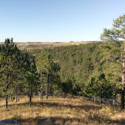
- Solitude and seclusion
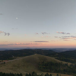
- Amazing views from the summit
Hike Summary
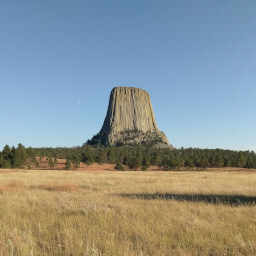
The Bearlodge Unit of the Black Hills National Forest is less visited than the other forest units in South Dakota, making this wilderness conveniently located along the drive to Devils Tower National Monument the perfect place to relax in seclusion. Sheepnose Mountain is one of the more remote hikes here, but the bumpy road and uphill climb rewards you with spectacular views. (Note: I didn't see these views myself due to fog and clouds but there isn't a single taller land mass to the east of this peak, so you should be able to see deep into South Dakota on a clear day). This hike is ideal for those who enjoy leaving the beaten path and trying a more adventurous, out-there hike to a place few people have seen.
The entire trail is very easy to navigate. Starting from the map kiosk, the trail starts as a one-lane road. Blue blazes with the letter M are found on trees throughout the hike; that letter M corresponds to the labels on a trail brochure you can pick up at the kiosk at Reuter Campground (and possibly the Reuter Trailhead) or the Black Hills National Forest office in Sundance.

Blue blazes with the letter M mark the Sheepnose Mountain Trail

You may encounter cows grazing at some point along the trail

This brown marker indicates you are heading the right direction

Follow the sign to Sheepnose Mountain

Pine trees planted in rows near the peak are especially creepy in the fog

Fog dowsing the rock formations at the summit of Sheepnose Mountain
Important Information
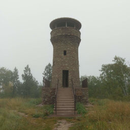
This remote trail is basically in the wild west, so you can have your dog off leash if you so desire, just note that cows may be grazing at any point along the trail and that a leash may be preferred. This is not a good trail for kids, so instead take them to Warren Peak Fire Lookout for easy views. You can hike here in the three warm seasons as long as the road to Warren Peak is open; in the winter access is much more difficult, but you could use the Sundance Trailhead on Government Valley Road for a very long approach with skis or snowshoes to Sheepnose Mountain. I doubt you will encounter anyone else on this trail, and you might not even see anyone on the dirt roads here either.
Directions
**Ensure that your navigation app follows this route or you might end up on rough, impassible, or closed roads!**
From Interstate 90 in Sundance, take the exit for U.S. Highway 14 and head west -- this is the same exit as used for Devils Tower National Monument. Turn right on Sundance-Warren Peak Road and continue straight to enter the Bearlodge Unit of the Black Hills National Forest. There is a gate partway up the mountain by the Reuter Trailhead that may be closed during inclement weather, prohibiting access to anything beyond. Turn right on a dirt road (labeled as 830.1 on the Motor Vehicle Use Map) just before the turnoff for Warren Peak Fire Lookout. This road is very narrow and rough in places; I survived the drive in a sedan, but I wouldn't recommend it if you actually like your car (I was in a rental). None of the dirt roads are marked, so pay attention and carry a map! Keep going straight, then stay right at the Y intersection ahead. A little further on the right side, you'll see the map kiosk for the Sheepnose Mountain Trail. I parked here rather than risking the one-lane road to the trailhead gate, but you can technically drive a bit more according to the Motor Vehicle Use Map. If you reach a four way intersection, you've overshot the trail.
Google Maps Directions
Parking, Fees, and Facilities
Parking is free! Either park by the map kiosk out of the way of the road or continue down the one-way road and park by the trailhead gate. There are no facilities here.
Nearby Hikes
Black Hills National Forest, Wyoming
★★★★★(5/5)
Devils Tower National Monument, Wyoming
★★★★☆(4/5)
Black Hills National Forest, South Dakota
★★★★☆(4/5)
Jewel Cave National Monument, South Dakota
★★★☆☆(3/5)