| Rating | ★★★★☆(4/5) |
| Overall Difficulty | Easy |
| Navigation Difficulty | Easy |
| Distance | 0.5 miles roundtrip |
| Time | 30 minutes |
| Terrain | A few hills |
| Best Seasons | All |
| Family Friendly | Yes |
| Dog Friendly | No |
| Accessible | Yes |
Highlights
- Learning about the pueblo's history
- The northernmost ball court ruins in North America
- The blowhole where air escapes a cave system
Hike Summary
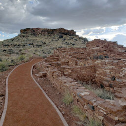
Wupatki Pueblo, meaning "tall house" in the Hopi language, is the largest ancient Native American building site near Flagstaff with over 100 rooms. Built by the ancestral Puebloan group known as the Sinagua (the same people who built Montezuma Castle) using sandstone blocks and mortar, the dwelling housed between 85 and 100 people. On this hike, you will learn more about the pueblo and its inhabitants, all while enjoying the beautiful emptiness of the desert.
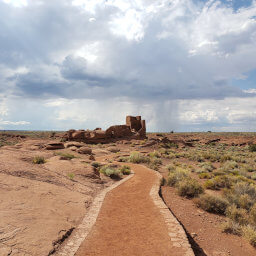
Before starting the hike, stop in the visitor center to pick up a free interpretive booklet. Along the trail, numbered signs correspond with the numbers in the booklet, providing more information about each section of the pueblo. To start the hike, follow the paved, accessible trail, eventually stopping at an overlook of the pueblo, as pictured below.

Wupatki Pueblo from the accessible overlook

Stairs leading down to Wupatki Pueblo
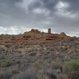
Continue straight at next intersection, then turn right on the spur trail to the kiva remains, pictured below. This round building served as a cross between a town hall and a church, a gathering place where the people of Wupatki discussed politics and performed religious rites. Kivas are found throughout the Four Corners region and were a common structure for many other groups of ancestral Puebloans.

The elliptical stone remains of the kiva

The remains of the northernmost ballcourt in North America

You can feel the air flowing out of the blowhole

Small rooms on the south end of Wupatki Pueblo
Important Information
Dogs are not allowed on any trails in the park; it's best to leave your dog at home since desert temperatures can kill dogs waiting in cars. This is an excellent hike for the whole family since it is short and educational, just make sure to keep kids away from the fragile ruins. The trail is wheelchair accessible up to an overlook of the pueblo, but stairs are required to hike the entire loop. You can visit during any season, but be prepared for wind. In the summer, temperatures can exceed 100 degrees and afternoon thunderstorms are common. Winter and early spring may bring snow, but not nearly as much as in nearby Flagstaff. Expect to see people here no matter when you visit.
Directions
From Flagstaff, take Interstate 40 east. Take the exit for U.S. Highway 89, then turn left. Turn right onto U.S. Highway 89. If you plan on taking the entire scenic loop road through Sunset Crater Volcano National Monument and Wupatki National Monument, turn right at the brown sign pointing to those two parks after about 12 miles, then turn left towards the visitor center after about 21 miles. Otherwise, continue straight on U.S. Highway 89 for about 26 miles, turning right near mile marker 444, as indicated by a brown sign for Wupatki National Monument, then turn right into the visitor center after about 13 miles.
Google Maps Directions
Parking, Fees, and Facilities
Entrance to the park is $25 per vehicle and permits access for 7 days to both Wupatki National Monument and Sunset Crater Volcano National Monument. Interagency passes are also honored here. Visit the park's fees page for more information. The staffed visitor center has restrooms and water in addition to educational exhibits and a gift shop.
Nearby Hikes
Coconino National Forest, Arizona
★★★★☆(4/5)
Wupatki National Monument, Arizona
★★★★☆(4/5)
Wupatki National Monument, Arizona
★★★★☆(4/5)
Wupatki National Monument, Arizona
★★★★☆(4/5)