Highpointing the Northeast
Last Updated by Ricky Holzer on Wednesday, November 6th, 2019
From Delaware's 442-foot Ebright Azimuth to New Hampshire's 6,288-foot Mount Washington, the Northeast includes a wide range of highpoints largely dominated by the Appalachian Mountains. Compared to the highpoints in the Midwest, the Northeast highpoints are much more difficult when they require some sort of physical effort, though both regions have the same amount of drive-up highpoints.
Thus far, I have visited 2 of the 12 Northeast highpoints, but I will attempt to rank the highpoints based on my own research and update as I climb more. Using my criteria for ranking of distance from a major city, difficulty of the hike (if any), and access restrictions with hike difficulty as the most important criterion, here is my ranked list of the Northeast highpoints from easiest to hardest to achieve. Note that for some drive-up highpoints, I took into account the difficulty of the easiest actual hike to the summit. At the bottom you can find a map of all 50 state highpoints (and U.S. territories too).
Northeastern Highpoints from Easiest to Hardest
Fort Reno, Washington, D.C. - 409 ft
Fort Reno is undoubtedly the most accessible highpoint in the entire U.S. considering you can take a subway to the park (getting off on the Tenleytown Red Line Station). With most of D.C. having an elevation slightly above sea level, this hill is relatively high, although it's still shorter than the top of the 555-foot Washington Monument.
Ebright Azimuth, Delaware - 448 ft
About 45 minutes from Philadelphia just across the Delaware border, Ebright Azimuth is only 103 feet taller than the shortest U.S. state highpoint, Britton Hill in Florida. The highpoint itself isn't much to see -- it consists of a sign and a USGS Benchmark along a sidewalk on Ebright Road.
Jerimoth Hill, Rhode Island - 812 ft
Another easy highpoint, Jerimoth Hill is a little over 30 minutes from Providence or an hour from Boston. A quick walk into the forest brings you to a rock outcropping and a sign designating the highpoint. While the trees block any sort of views, the drive here is scenic with plenty of rolling hills and forest -- especially beautiful in the fall.Mount Davis, Pennsylvania - 3213 ft
The highest point in Pennsylvania is Mount Davis, located about 2 hours southeast of Pittsburgh. You can either drive almost the entire way to the top or hike about 2 miles roundtrip with 200 feet of elevation gain. At the summit, you can climb an observation tower for views above the dense forest -- the top of the mountain is extremely flat so there's not much in the way of views otherwise!
High Point, New Jersey - 1803 ft

High Point Monument from across Lake Marcia
Read my post about High Point.
High Point is home to the largest state highpoint monument, a massive stone obelisk visible for miles (I thought it was a radio tower from a distance). This is another drive-up highpoint, located about 2 hours from New York City. Another, more difficult option is to hike a section of the Appalachian Trail to the Monument Trail; in addition, you can climb the many, many stairs to the top of the monument for a $1 fee. Despite New Jersey's reputation as America's armpit, the view is quite beautiful with views of rolling, forested hills in every direction and a glimpse of the Delaware River to the west.
Mount Greylock, Massachusetts - 3491 ft
Located in the far northwest corner of Massachusetts about 3 hours from both Boston and New York City (and only an hour north of Connecticut's highpoint), Mount Greylock is another drive-up highpoint. Much like New Jersey's highpoint, there is a war memorial tower at the top that you can climb for higher views. Hiking up the mountain presents more of a challenge, and the shortest trail requires 4 miles roundtrip and 2275 feet of elevation gain. There are several waterfalls found on various trails to the summit, so whatever route you choose, it will be scenic!
Spruce Knob, West Virginia - 4861 ft
In addition to being West Virginia's highest point, Spruce Knob is also the tallest peak in the Allegheny Mountains and Appalachian Plateaus. You can drive most of the way to the top, though it's around 4 hours from either Pittsburgh or DC, and then hike less than half a mile roundtrip to reach the summit and observation tower. However, the alternative routes are quite long, involving 16 miles roundtrip and 1000 feet of elevation gain on the Huckleberry Trail.
Mount Frissell, Connecticut - 2380 ft
A little under 3 hours from New York City near the tri-state border, the highest point in Connecticut is located on the southern slope of Mount Frissell rather than the summit (which is located in Massachusetts). Hiking is required for this highpoint, with a minimum of around 2.5 miles roundtrip and 500 feet of elevation gain. The highpoint itself isn't very scenic since it's on a trail in the middle of the forest, but climbing to the true summit of the mountain or the summit of other nearby mountains in the Taconic Range will give you the views you crave.
Backbone Mountain, Maryland - 3360 ft
Along the West Virginia border, you'll find Backbone Mountain and Maryland's highest point (which is also about an hour south of Pennsylvania's highpoint). The hike to the top isn't very long at 2 miles roundtrip, but the 700 feet of elevation gain means the trail is steep. The views at the top are decent, but are best when there are fewer leaves on the trees.
Mount Mansfield, Vermont - 4393 ft
Though it's about 900 feet shorter than a mile, Mount Mansfield is located far enough north that the top hosts an alpine, sub-arctic environment more similar to places much further north in Canada. Hiking to the top requires a challenging but scenic day hike with around 6 miles roundtrip and 2600 feet of elevation gain (more or less depending on the route).
Mount Washington, New Hampshire - 6288 ft
Mount Washington is the highest mountain in the Northeast, over 900 feet higher than the next tallest state highpoint (Mount Marcy in New York). Technically, you can drive to the top, a 3-hour trip from Boston. However, actually hiking to the top requires at minimum a 8.4 mile hike with about 4200 feet of elevation gain via the Tuckerman Ravine Trail. Some lists place Mount Washington near the easiest, but I rated it harder assuming you actually want to do some hiking.
Mount Marcy, New York - 5344 ft
Climbing Mount Marcy is no easy task, requiring a 15 mile hike and 3700 feet of elevation gain on the easiest route. I've ranked it as the second hardest because it requires less elevation gain and is a more gradual (albeit longer) trail than Mt. Katahdin in Maine. Take this with a grain of salt since I haven't climbed this mountain yet.
Mount Katahdin, Maine - 5267 ft
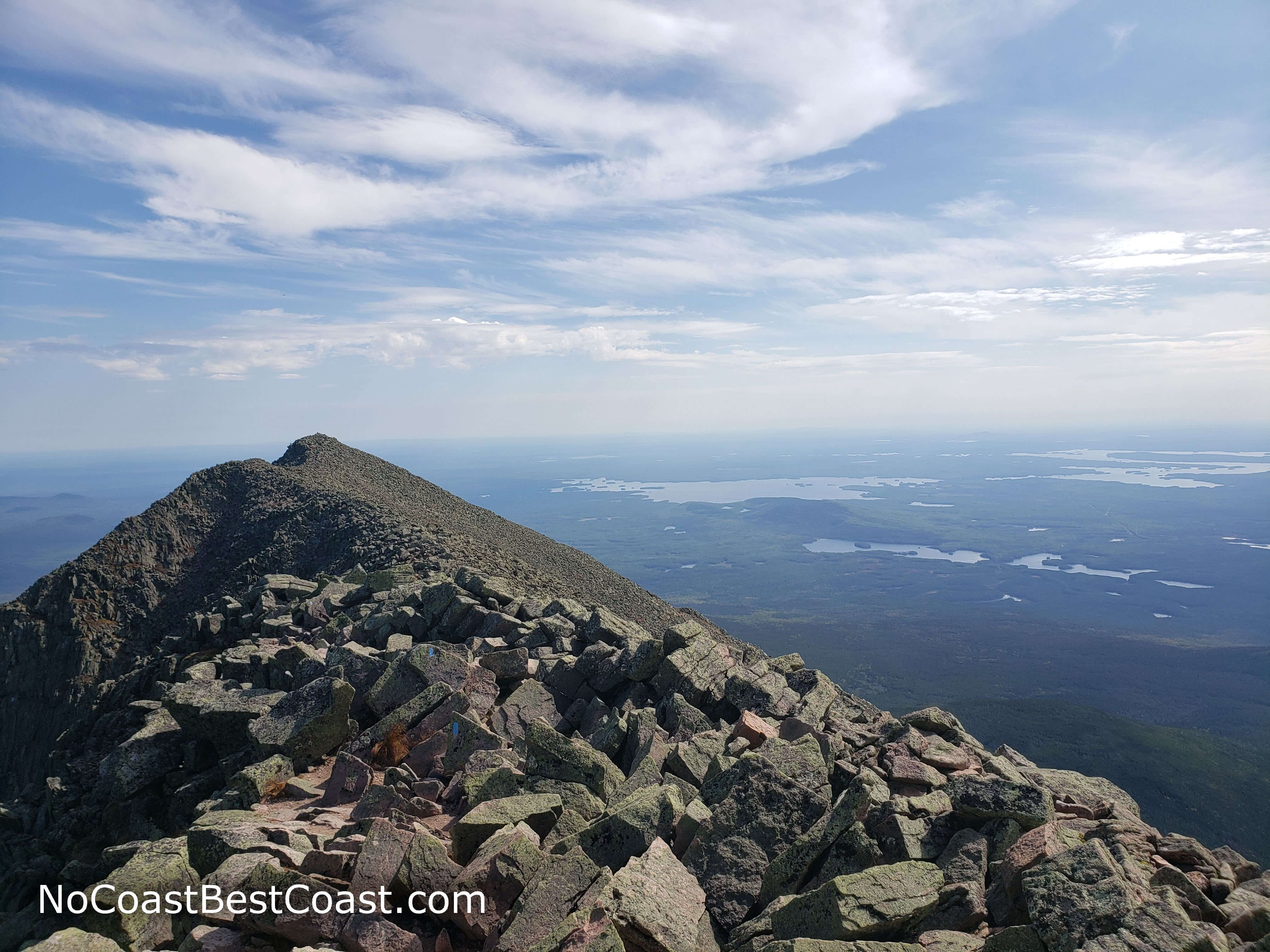
The view from the top of Mt. Katahdin
Read my post about Mount Katahdin.
Often referred to as the only "western peak" found east of the Mississippi, Mount Katahdin is a formidable climb no matter which route you take -- shockingly, 23 people have died on the Knife Edge Ridge route since the 1960s. This adventure requires a 5-hour drive from Boston to Maine's largest wilderness and a subsequent 8-10 hours roundtrip of hiking and scrambling on at least 10.4 miles of trail with over 4000 feet of elevation gain. Don't let that scare you though, because the climb is also one of the most beautiful natural experiences in the entire Northeast with stunning views once above treeline. If you can handle this mountain, you're ready for the easier highpoints in the West, like Texas's Guadalupe Peak or Arizona's Mount Humphreys.
You can also read about all the highpoints in the Northeast and beyond at SummitPost.com. Happy highpointing! Let me know what you think in the comments section below and be sure to use #nocoastbestcoast on Twitter and Instagram!