| Rating | ★★★★★(5/5) |
| Overall Difficulty | Hard |
| Navigation Difficulty | Easy |
| Distance | 6.8 miles roundtrip |
| Time | 3.5 hours |
| Terrain | Strenuous climbing |
| Best Seasons | Spring, Fall |
| Family Friendly | No |
| Dog Friendly | Yes |
| Accessible | No |
Highlights
- Unobstructed panoramic views of the Black Hills
- Towering granite rock formations throughout the loop
- Side trip to Little Devils Tower
Hike Summary
As my 8th state highpoint, I can say without a doubt that the route to Black Elk Peak (formerly known as Harney Peak) is the most outstanding hike out of all the Midwest highpoints. Standing at 7,242 feet above sea level, Black Elk Peak is not only the highest point in the Midwest by over 1800 feet above the next highest point (Panorama Point in Nebraska), it's also the highest point east of the Rocky Mountains. For you, this means that you will have unrivaled panoramic views of the Black Hills that extend far across the flat prairie surroundings to Badlands National Park over 50 miles due east. Most people try to do this hike the "easy way" doing Trail #9 both directions, but they are missing half of the scenery just to cut off mere tenths of a mile from the roundtrip distance! Instead of being "done" once you reach the peak, you'll hike past the towering Cathedral Spires and impressive Little Devils Tower, with a chance to climb the latter as a side trip.
Trail #9 is the more gradual of the routes to the top, so it's best to do this loop clockwise. From Sylvan Lake (pictured below), follow signs for Trail #9 to Black Elk Peak. You'll know you're heading in the right direction if you see several warning signs about how dangerous the hike is and how you need to be prepared with ample water, clothing, and food. On that note, the summit is notoriously windy and a few degrees colder than Sylvan Lake, so packing another layer or two is essential. In addition, it's easy to underestimate this hike if you've never climbed a real mountain before (not many chances for that in the Midwest...), so be prepared with more water and snacks than you usually bring. The trail is quite rocky with stair-step like portions and eventually actual staircases. Don't be ashamed of taking breaks (or when 5 year olds or 78 year olds pass you), and take care of yourself. Inclement weather is highly likely, especially in the summer, so turn around to avoid the high, treeless peak when a thunderstorm approaches.

Beautiful Sylvan Lake welcomes you at the trailhead

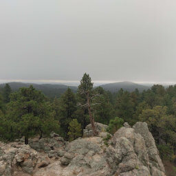
Meadows and pine covered rocky hills during the first part of the hike

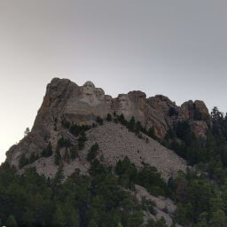
Black Elk Peak (center) and its mass of rocks as seen from an overlook

All hikers must stop and fill out a permit form when entering the Black Elk Wilderness

The last section involves climbing several staircases

The lookout tower marks your final destination

The view looking south towards your next destinations: the Cathedral Spires and Little Devils Tower

The view looking east towards Mount Rushmore and Badlands National Park
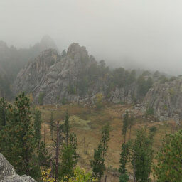
Because this part of the hike is less traveled, the trail can be harder to find in places. Trail #3 eventually intersects with Trail #4, and you will continue straight to take Trail #4 towards Little Devils Tower (staying on Trail #3, also called the Grizzly Bear Trail after this intersection, will take you deeper into the wilderness). Looking back at the map, I don't remember seeing this intersection, so in any case you can't go wrong by going straight. After a mostly flat walk through the deadfall area, the trail starts ascending to a saddle, and at the top you'll have a great view of the Cathedral Spires, pictured below.

The Cathedral Spires as seen from the saddle
After passing the side trail to Little Devils Tower, the trail zigzags down to the meadow lined with granite boulders pictured below. You'll start seeing more people again, since many opt to do only the short hike to Little Devils Tower. From here on, the grade is much more gradual until you reach the parking area for the Little Devils Tower Trailhead. From this parking lot, look for the trail just past the two restrooms heading northeast and slightly uphill (groan). After such a long trek, this final segment will feel like an eternity, especially because it isn't particularly scenic.

Returning to the rock-lined grassy meadows
Important Information
Dogs are allowed on leash. This trail is much too difficult for children (though I did see some parents dragging their kids to the top during my visit); a better option for kids is the mile-long Lake Shore Trail around Sylvan Lake. Spring and fall are the best times to hike to the peak to avoid the violent thunderstorms common in summer. If hiking in the summer, start as early in the day as possible and bring lots of water to brave the heat. Access to Sylvan Lake during winter is dependent on weather conditions, and most roads close for the season. This is a tremendously popular hike, and the entire way up on Trail #9 is likely to be full of people while Trail #4 on the return trip will feel empty in comparison.
Directions
From Custer, take U.S. Highway 16A east, then turn right onto South Dakota Highway 89 (Sylvan Lake Road). Turn right onto South Dakota Highway 87, following the signs pointing towards the entrance to Custer State Park. Pay the entrance fee at the station, then turn left into the Sylvan Lake area shortly after the station and find a parking spot.
From Rapid City, take U.S. Highway 16 west towards the Black Hills. Turn left onto U.S. Highway 385, then turn left on South Dakota Highway 87. Turn left to stay on South Dakota Highway 87 and enter Custer State Park. Pay the entrance fee at the station, then turn left into the Sylvan Lake area shortly after the station and find a parking spot.
Google Maps Directions
Parking, Fees, and Facilities
The entrance fee to Custer State Park is $20 for a weekly pass or $30 for an annual pass -- more information is available on the official park website linked at the bottom of the page. Sylvan Lake is extremely popular and finding a parking spot may be difficult during the peak season. If the lot is full, return to the main road and turn left, then park at the Little Devils Tower Trailhead on the left side of the road; since this is a loop hike, you'll simply be starting in a different spot. The Sylvan Lake area has both flush and pit toilets, a picnic area, swimming area, boat launch, and full service lodge. The Little Devils Tower Trailhead has pit toilets.
Nearby Hikes
Black Hills National Forest, South Dakota
★★★☆☆(3/5)
Mount Rushmore National Memorial, South Dakota
★★★★☆(4/5)
Black Hills National Forest, South Dakota
★★★★☆(4/5)
Custer State Park, South Dakota
★★★★☆(4/5)